Stanislav POPELKA
Eye movement analysis is a rich source of information that can be used to understand a person’s cognitive state, and interpret their cognitive processes as she/he executes visuospatial tasks. Eye-tracking, thus, is an important technique for evaluating and optimizing map design, geographic and other information visualizations, and a wide variety of cartographic products such as map-like displays including 3D representations. In cartography and related fields, understanding the perceptual and cognitive processes involved in tasks such as map reading, route learning and navigation not only enhances our understanding of human factors, but also leads to improved design decisions. With decreasing prices of eye-tracking devices in recent years, as well as promising developments in eye-tracking on smartphones, head-mounted devices, and in extended reality, we see an unprecedented amount of eye movement studies and data in cognitive cartography. Moreover, these technological developments have led to an increased use of eye-tracking for the design of gaze-based interaction, including also the interaction with maps.
Habilitation thesis summarizing use of eye-tracking in cognitive cartography
EXPERIMENTS
SELECTED PUBLICATIONS
Popelka, S., Burian, J., Beitlová, M. (2022) Swipe Versus Multiple View: A Comprehensive Analysis Using Eye-Tracking to Evaluate User Interaction with Web Maps, Cartography and Geographic Information Science, DOI: 10.1080/15230406.2021.2015721
Šašinka Č, Stachoň Z, Čeněk J, Šašinková A, Popelka S, et al. (2021) A comparison of the performance on extrinsic and intrinsic cartographic visualizations through correctness, response time and cognitive processing. PLOS ONE 16(4): e0250164.
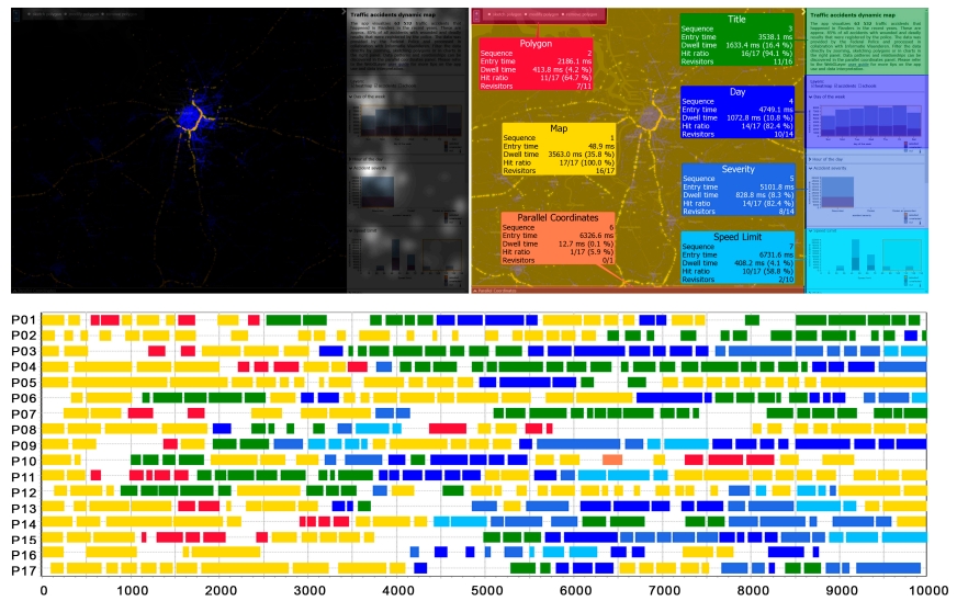
Popelka, S., Herman, L., Řezník, T., Pařilová, M., Jedlicka, K., Bouchal, J., Kepka, M., Charvat, K. (2019) User Evaluation of Map-Based Visual Analytic Tools, ISPRS International Journal of Geo-Information, 8(8), 363; doi:10.3390/ijgi8080363
Brus, J., Kučera, M., Popelka, S. (2019): Intuitiveness of geospatial uncertainty visualizations: a user study on point symbols. Geografie, 124, 2, 163-185.
Popelka, S., Vondrakova, A., & Hujnakova, P. (2019). Eye-Tracking Evaluation of Weather Web Maps. ISPRS International Journal of Geo-Information, 8(6), 29. doi:10.3390/ijgi8060256
Popelka, S. (2018): Eye-tracking analysis of the influence of relief shading on finding labels on tourist maps. Geografie, 123, 3, 353–378.
Burian, J., Popelka, S., & Beitlova, M. (2018). Evaluation of the Cartographical Quality of Urban Plans by Eye-Tracking. ISPRS International Journal of Geo-Information, 7(5), 192.
Popelka, S. (2018). Eye-Tracking Evaluation of Non-Photorealistic Maps of Cities and Photo-Realistic Visualization of an Extinct Village. In R. A. White, A. Coltekin, & R. R. Hoffman (Eds.), Remote Sensing and Cognition Human Factors in Image Interpretation (pp. 87-110). Boca Raton, FL: CRC Press.
Opach, T., Popelka, S., Dolezalova, J., Rod, J.K. (2018) Star and Polyline Glyphs in a Grid Plot and on a Map Display: Which Perform Better?, Cartography and Geographic Information Science, 45(5), DOI: 10.1080/15230406.2017.1364169